
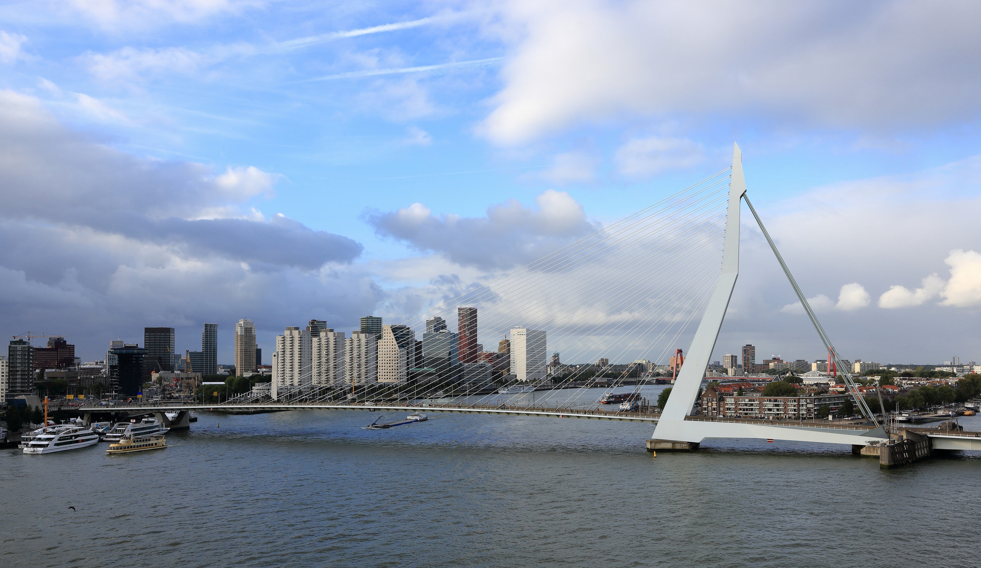
A river can make a city look beautifully simple. Stand back, find the bridge, put the skyline on the far bank: the picture seems to arrange itself. In Rotterdam, that first composition is worth keeping, but it should not be the only one. The Nieuwe Maas is a working waterway. Elsewhere, a sunken sports court has a second job when rain arrives. Water shapes the city through movement, storage and maintenance as well as through a view.
This is the opening proposition of At the Waterline: a waterfront becomes more interesting when we ask what it does. Who needs to cross it? Which activities depend on its depth? Where does rain go after it leaves a roof? Rotterdam gives those questions an unusually tangible scale. A bridge offers the long line; a neighbourhood square brings the subject within reach of a gutter. Between them is a way of travelling that pays attention to the systems beneath a city without turning the visit into an engineering lecture.
Start with a crossing
The Erasmus Bridge is the obvious introduction, and there is no need to resist an obvious introduction when it is a useful one. It connects the northern and southern sides of Rotterdam across the river. Its pale pylon and spread of cables give the crossing an identity that remains clear against the buildings behind it. Look at it first from the bank, where the structure can be read as a whole, before deciding whether to cross.
A pedestrian crossing changes the picture slowly. The near bank falls into a different relationship with the opposite skyline, while the river occupies the space between them. This is a good place to separate a photographic stop from the business of walking. Choose somewhere that does not obstruct other people, make the photograph, then move on. A bridge remains a route to work and home, even when it has become a city's emblem.
There is no editorial obligation to walk the entire span in poor conditions. Exposure is part of a bridge's geography, and a route that looks modest on a map can feel different in wind and rain. The better plan leaves room for public transport or a shorter riverside circuit. Seeing a place carefully is not measured by the number of kilometres completed against the weather.
The waterway has other users
The Port of Rotterdam describes the area around the Erasmus Bridge as one of the Nieuwe Maas's busiest waterways. Its published navigation measures, introduced in April 2026, are a useful reminder that the activity in a river photograph is managed, not spontaneous. Visitors on land do not need to memorise vessel speed limits. They do need to recognise that crossings, berths and working edges are parts of an operating port city.
Watch from public space. Keep access to boarding points and service areas clear, and do not treat an apparently empty landing as an invitation to step onto it. If a boat journey forms part of the day, choose an identified operator and check the actual sailing and boarding arrangements. The presence of a vessel in an archive photograph says nothing about its current route, timetable or suitability.
It is tempting to make every moving object into scenery. A more rewarding reading is to keep the purpose in view: somebody is transporting passengers, supplying a business or moving freight. That shift does not make the river less beautiful. It supplies the missing verbs. The bridge carries; the vessel delivers; the bank connects. The city begins to look less like a collection of objects and more like a set of relationships.
A square with a second job
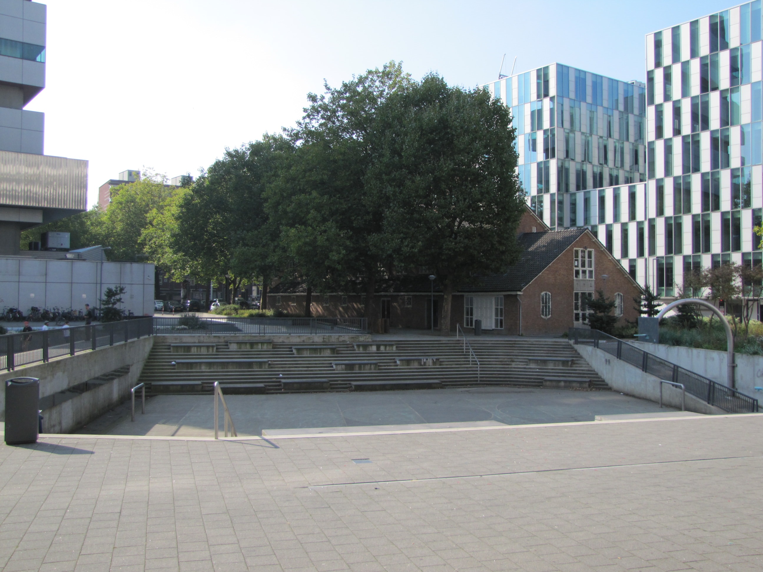
Benthemplein introduces a different sort of water story. Designed by De Urbanisten and completed in 2013, the square combines public recreation with stormwater storage. Its basins are intended to be used as space when dry and to hold rainwater when conditions require it. Here, the question is not how to cross a river but how a dense neighbourhood can make room for rain.
The municipality describes three basins with a combined capacity of approximately 1.7 million litres. Treat that figure as a clue to the scale of the design, rather than as a guarantee against every kind of flooding. Stormwater management and defence against high river levels are not interchangeable tasks. A square can make a particular contribution without being a complete answer to a city's exposure.
The design team records a process involving local residents and neighbouring organisations. That matters to the visitor's reading of the place: it was conceived as usable neighbourhood space, not simply as a demonstration for an outside audience. Arrive with the same consideration you would bring to any public court or small park. Leave activities undisturbed. Do not descend into a basin that is holding water, and follow any closure or maintenance notices.
Read the section, not only the surface
The revealing thing about a water square is the change in level. Steps, edges and channels are not merely a graphic pattern seen from above; they describe what can happen across the ground. In dry weather, a visitor can follow that logic without needing a dramatic storm to make the place meaningful. A drawing would call it a section: the relationship between the surface where people stand and the spaces below it.
De Urbanisten's account describes visible gutters and different basins, giving the movement of rain a place in the design. The square encourages an exercise in observation. Look for a route into a depression, then look for the boundary between a recreation area and a circulation route. Ask which parts would remain legible when the usual pattern of use changes. Avoid assuming that every drain or channel serves the same function.
The lesson travels well, but it should not become a competition in which one city supposedly solves water for everyone else. Different places have different ground conditions, responsibilities and resources. What a traveller can take away is a better question: how does a public space accommodate more than one need, and who looks after the point where those needs meet?
Below the pavement
Rotterdam's municipal explanation distinguishes water squares from underground storage and water buffers. Some measures hold excess water temporarily; others retain it for later use. Not all of this infrastructure offers a visible attraction, and much of it would be easy to walk over without recognising its role. That is not a failure of the visit. A city is allowed to function without turning every necessary system into an exhibit.
The distinction also helps resist a familiar shortcut in travel writing: treating one memorable project as a summary of an entire place. Benthemplein is a useful example, not the whole water network. The Erasmus Bridge is a powerful image, not the whole port. Holding those limits in mind makes the account more precise and leaves space for ordinary streets, businesses and homes that do not appear in the promotional photograph.
There is pleasure in this more modest form of attention. A short stretch of pavement can become interesting because of an explanation read beforehand, rather than because it has been labelled a must-see. Carry the explanation lightly. Nobody needs to inspect every gutter. One carefully understood space can sharpen the rest of a day's wandering without dictating every turn.
Make a day with two anchors
For a first visit, the river crossing and the water square are enough to give the day a structure. Treat them as separate anchors rather than drawing the straightest possible line between them and assuming the intervening journey is negligible. Check the route from your actual starting point. Decide where you will pause indoors, and keep any booked activity far enough from the end of a long walk to avoid a rushed transfer.
Use the rest of the day for a neighbourhood-scale choice rather than another cross-city obligation. A meal, an exhibition or an unhurried return to the river can all deepen the visit. If the afternoon becomes wet, the outside stops can be shortened without destroying the day's idea. The relationship between water and the city will still be there when the light changes.
This is particularly useful for a group with different walking capacities. Agree on the essential meeting point and the optional extension before setting out. A person who remains on the bank has not failed to experience the bridge. A person who prefers an indoor interval should not have to negotiate that preference only when everyone else is already tired.
Practicalities without false precision
The currency is the euro. Separate the cost of staying in Rotterdam from the cost of looking at the city: accommodation, meals, transport and paid interiors are different parts of the budget. An itinerary built around public outdoor space still needs an allowance for weather, fatigue and the occasional unexpected transfer. Check the terms of any attraction ticket directly instead of assuming that a transport product includes admission.
For occasional public-transport journeys, OVpay allows check-in and check-out with supported contactless cards or devices. Its own guidance stresses using the same card or device at both ends. A physical card and its version on a phone should not be treated as interchangeable during one journey. Verify eligibility and any discount arrangements with the operator, especially when travelling with children or using a concession.
Do not infer step-free access from a route being short or centrally located. A bridge approach, station interchange and sunken court present different questions. Travellers who need a particular access arrangement should check each relevant operator or venue. The useful question is specific: where is the entrance, which level does it reach, and what alternative exists if that approach is unavailable?
Leave with a better map
A conventional souvenir of Rotterdam might be the bridge against the skyline. Keep it. Alongside it, remember the less immediately spectacular idea of an area of public ground designed to have another use when it rains. One image records a connection across water; the other records room made for water. Together they describe a city as something continually negotiated.
Neither asks the visitor to pretend to have mastered the place. An afternoon cannot explain a port, and a water square cannot explain every decision about climate adaptation. Travel is more convincing when it admits the scale of what remains outside the frame. It can still produce a useful change in perception: the next attractive waterfront may prompt questions about work, access and maintenance before it prompts a search for the best angle.
That is the invitation at the beginning of this issue. Read the waterline as an active edge, with people and responsibilities on both sides. Follow the public route, respect the working one, and allow a practical detail to become part of the memory. Rotterdam's generous lesson is not that water can be made simple. It is that a city becomes more legible when we stop asking it to be.
“A waterfront becomes more interesting when we ask what it does.”
A considered route
- First intervalRead the crossing
Begin from a public bank near the Erasmus Bridge. Cross only if weather and access suit the group.
- Second intervalRead the water square
Visit Benthemplein as neighbourhood space. Observe the dry basin and channels without disturbing activities.
- Leave roomAn indoor pause
Choose one nearby indoor interest and a meal; check admission and connections on the day.